Some
comments by one of my students led me to do some
reading about "Adam's Bridge" aka "Rama's Bridge" aka "Ramu setu "
aka "Shri Rama Sethu," etc.; this is something that I had never heard about before.
You will recall from
your reading of the Ramayana that Rama had to
rescue Sita from the demon king Ravana who was holding her in Lanka
(aka Sri Lanka aka Ceylon), an island south of India. Hanuman, Rama's comrade, with his army of monkey-men
built a "bridge," or causeway, across the narrow strait from India to Sri Lanka to
reach the island. There a great battle took place before Rama and
Hanuman defeated Ravana and liberated Sita. The bridge is known, in English, as "Adam's Bridge."
If you do a search for information about "Adam's Bridge" on the web, you will find a number of websites such as NASA Images Discover Ancient Bridge (Adam's Bridge) between India and Sri Lanka, and all of these sites use NASA, or other official agency pictures, to declare that there now exists evidence that confirms the validity of the Ramayana through the now-proven existence of Rama's Bridge. If true, this would affirm some of the Hindu religious beliefs of Indians.
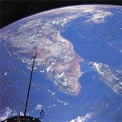
Another 2002 NASA photograph of Sri Lanka is often cited as conclusive evidence of the "bridge."
The Encyclopedia Britannica (Retrieved 4 February 2008) defines the "bridge" as a
chain of shoals, between the islands of Mannar, near northwestern Sri Lanka, and Rameswaram, off the southeastern coast of India. The bridge is 30 miles (48 km) long and separates the Gulf of Mannar (southwest) from the Palk Strait (northeast). Some of the sandbanks are dry, and nowhere are the shoals deeper than 4 feet (1 m); thus, they seriously hinder navigation....Traditionally, it is said to be the remnant of a huge causeway constructed by Rama, the hero of the Hindu epic Ramayana, to facilitate the passage of his army from India to Ceylon (Sri Lanka) for the rescue of his abducted wife, Sita. According to Muslim legend, Adam crossed there to Adam's Peak, Ceylon, atop which he stood repentant on one foot for 1,000 years.
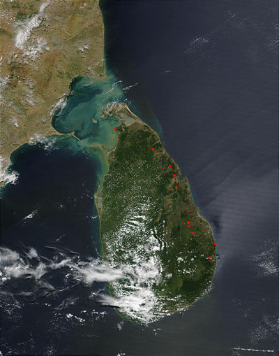
I found some further, very interesting information about the "bridge" in the blog of Suvrat Kher, a professional geologist specializing in marine formations:
Adam's Bridge is a chain of sand shoals and coral islands which appear as stepping stones along the Palk Strait. Everyone accepts that these are natural features. The controversy is whether there is a causeway linking these islands....The one [image] above, of the Palk Strait is the NASA image that has contributed to the controversy. The perception of continuity is however an illusion caused by a combination of cloud cover and suspension of white calcium carbonate sediment along the length of the coral islands. The next image shows a close up of the Palk Strait. The discontinuous nature of the islands is clearly seen. The images are inconclusive on the issue of the causeway....This is a controversial issue involving the religious sentiments of millions of Indians. I feel though that any detailed geological investigation of the Palk strait sediments will be able to explain Adam's bridge as a natural consequence of sand shoal formation and coral reef dynamics.
Besides the many websites trumpeting the existence of the "bridge, there are a few, such as this short news brief,
NASA debunks Rama
bridge theory, that are a bit more critical:
"Remote sensing images or photographs from orbit cannot provide direct information about the origin or age of a chain of islands, and certainly cannot determine whether humans were involved in producing any of the patterns seen," said NASA official Mark Hess....NASA said the mysterious bridge was nothing more than a 30 km long, naturally-occurring chain of sandbanks called Adam's bridge. Hess said his agency had been taking pictures of these shoals for years. Its images had never resulted in any scientific discovery in the area.
So, while there is, without a doubt, something of a land link between India and Sri Lanka, the evidence is not yet there, despite the evocations of an ancient religious and literary traditon, to prove the existence of Rama's Bridge.

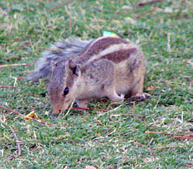
So, why have I included the picture of this nice, little squirrel? Well, according to tradition, the squirrel helped build the causeway by rolling sand grains down to the water. Therefore, as a sign of gratitude, Rama is said to have stroked the back of the squirrel which is why all Indian squirrels have the three dark lines on their backs from where the three fingers of Rama touched them.
Some recommended online lectures and websites
- Rama, Ravana & Sita: Road to Ramayana by Sirancee Gunawardene
- Complete Information about Sethusamudram
- Wikipedia actually has a pretty good summary of information on Adam's Bridge
- NASA Images Find 1,750,000 Year-Old Man-made Bridge between India and Sri Lanka
- Adam's Bridge
- For extra credit please suggest to your instructor a
relevant website for this unit of the course.
Send the title of the site, the url and a brief explanation why you find the information interesting and applicable to the material being studied in this unit.