 |
The LANDSAT Program(Created by Thomas Alcorn, History 135, August 2007)Assignment Background Chronology Links Further Reading |
 |
|
The LANDSAT Program(Created by Thomas Alcorn, History 135, August 2007)Assignment Background Chronology Links Further Reading |
|
CHRONOLOGY |
|
| October 4, 1957 |
Sputnik I (Russian) is launched. About the size of a basketball, the first artificial Earth satellite weighs 184 pounds and takes about 98 minutes to complete one orbit. |
| January 31, 1958 |
The United States launches its first satellite, the 30.8-pound Explorer 1. |
| April 12, 1961 |
First Man in Space: Russian Cosmonaut Yuri Alekseyyevich Gagarin aboard the Vostok 1 Spacecraft |
| August 14, 1966 |
U.S. Lunar Orbiter 1 enters moon orbit, and takes the first picture of the Earth from the distance of the moon. |
| December 21, 1968 |
Apollo 8 flight to the moon. As the ship travels outward, the crew focuses a portable television camera on Earth and for the first time humanity sees its home from afar, a tiny "blue marble" hanging in the blackness of space. |
| July 20, 1969 |
First Manned Moon Landing: Neil Armstrong and Edwin Aldrin, Jr. became the first humans to set foot on another world. |
| November 13, 1971 |
American space probe Mariner 9 is the first spacecraft to orbit another planet, Mars. 100% of the Martian surface is mapped over the next year. |
| July 23, 1972 |
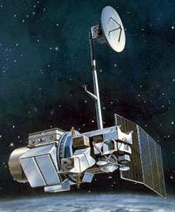
Landsat-1 Launched |
| May 14, 1973 |
First U.S. Space Station: Skylab is launched. |
| May 17, 1974 |
NASA launches the first Synchronous Meteorological Satellite, SMS-1. |
| January 22, 1975 |
Landsat-2 Launched |
| 1975 |
NASA changes ERTS program name to Landsat. |
| August-Septeber, 1977 |
Voyager 1 and Voyager 2 are launched to meet with Jupiter in 1979 and Saturn in 1980. |
| January 6, 1978 |
Landsat-1 Decomissioned |
| March 5, 1978 |
Landsat-3 Launched |
| April 12, 1981 |
First Space Shuttle Columbia is launched. |
| February 25, 1982 |
Landsat-2 Decomissioned |
| July 16, 1982 |
Landsat-4 Launched |
| March 31, 1983 |
Landsat-3 Decomissioned |
| March 1, 1984 |
Landsat-5 Launched |
| July 17, 1984 |
Land Remote Sensing Commercialization Act : Facilitated the commercialization of the Federal Government's civilian land remote-sensing satellite system, known as Landsat. |
| October, 1985 |
EOSAT takes control of Landsat-4 and Landsat-5. |
| April 24, 1990 |
Hubble Space Telescope is launched. While the telescope is successfully deployed, the primary mirror is seriously flawed resulting in fuzzy images. |
| October 28, 1992 |
Land Remote Sensing Policy Act: Authorized the procurement of Landsat 7 and assured the continued availability of Landsat digital data and images. |
| October 5, 1993 |
Landsat-6 Launch failure |
| December 14, 1993 |
Landsat-4 Set to "Standby" |
| 1995 |
EOSAT acquired by Space Imaging |
| May 18, 1996 |
X Prize competition announced: 10 Million dollars to the first person or team to safely launch and land a spacecraft capable of carrying three people to a suborbital altitute or 100km and repeat the trip again within two weeks. This contest is designed to inspire and jumpstart civilian and commercial space programs. |
| April 15, 1999 |
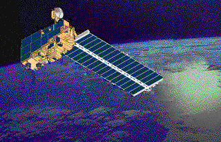
Landsat-7 Launched |
| August 2001 |
Landsat-5 MSS powered off |
| July 1, 2001 |
Space Imaging relinquishes Landsat commercial rights and operational control of Landsats 4 and 5 to USGS. |
| December 15, 2001 |
Landsat-4 Decomissioned |
| November 1, 2005 |
Landsat-5 TM ops suspended |
| January 12, 2006 |
Space Imaging aquired by ORBIMAGE. The combined company was rebranded as GEOEYE, the world's largest commercial remote-sensing company. |
| January 30, 2006 |
Landsat-5 Resumed TM ops |
| 2011 |
Proposed LDCM Launch Date |
This
page is copyright © 2004, S. Stanley and C.T. Evans
For information contact cevans@nvcc.edu